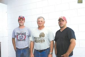
A team traveling the North Shore to complete a U.S. Department of Agriculture (USDA) Natural Resources Conservation Service (NRCS) soil survey has been making good progress despite bugs, rain, and getting lost.
Tom DeWitt, of Rogersville, Missouri, a retired USDA soil scientist and instructor at Missouri State University, and grad students Ben DeWitt and Cody Wallace are one of the teams conducting soil surveys in Cook and Lake counties. Cook and Lake are the only counties in Minnesota which have not had soil surveys done. DeWitt and his students are tasked with surveying the U.S. Geological Service (USGS) Grand Marais quadrangle, which is 32,000 acres. The quadrangle is broken down onto four worksheets and they were nearly finished with the third sheet when the Cook
County News-Herald
visited with them on July 23.
“We’re basically inventorying all of the soils in the county. We are taking samples on the ridge top, side-slopes and down in valleys to get a representative sample of all the soils,” said Tom DeWitt.
DeWitt’s team has discovered one thing most Cook County residents already know—there is a lot of rocky soil everywhere in the county. Tom DeWitt said, “We’ve found a lot of swamps, clay—and lots of rock. The hardest part is getting two feet down for samples.”
He said in some areas the team has used a Giddings power auger to get to a depth of six feet. Once collected, the sample is put in a correlation box for further study. The soil survey will determine which of the 400–1,000 different soils in the state of Minnesota are found in Cook County. While they are in the field, the team is also completing a vegetative survey, reporting on what type of vegetation is present in particular soils.
Collecting all these samples has been challenging for the Missouri trio. Ben DeWitt said the bugs haven’t been too bad and they haven’t minded the frequent rain too much, but making progress through all the downed trees has been difficult. “It’s toughest in the areas where there are no trails,” he said.
And the high iron content of Cook County soils has caused problems with compasses. The men had been told about that iron could cause problems and they even traveled to the recently opened Chik Wauk Museum & Nature Center at the end of the Gunflint Trail to learn more about the unique geological characteristics of the Magnetic Rock area.
However, the getting-lost incident was due to human error. Ben DeWitt said the plan was to walk out into a swamp to get a soil sample on a road near County Road 6 in Grand Marais. The compass used to chart progress was carried by a team member who also carried a special soil survey tool, the Montana sharpshooter. The tool is a special heavy-duty spade that makes a deep, narrow, hole. It is designed for use in rocky soil and has a solid steel handle—something that played havoc with the team’s compass, sending them off track.
“Once we realized we were lost, we called 911,” said Tom DeWitt. “At that point we didn’t trust our compass.”
Theteam gave its location to the law enforcement dispatcher who was able to locate the men on a map and direct them back to the road. “Our mistake was we hadn’t marked the truck on the GPS when we started out. We were lucky that we had cell phone service and that law enforcement dispatch was able to help us out,” said Tom DeWitt. “Themoral of the story is if you’re using GPS, be sure to mark your truck location when you start.”
The team will continue its work until August 15, using a pickup with NRCS signage and four-wheelers. They have permission from the US Forest Service to use the all-terrain vehicles on snowmobile trails to access soil collection sites. They also collect soil samples on private property throughout the county, but only after obtaining the landowner’s permission. No soil samples have been collected in the Boundary Waters Canoe Area Wilderness (BWCAW) yet and Tom DeWitt said if or when those samples need to be taken, the team would comply with wilderness restrictions. He said it is possible that the USDA would use aerial imaging for the wilderness area.
Thesurvey will not be completed this year. The Missouri team hopes to come back to finish the project in the summer of 2011.
There is no cost to Cook County for the soil survey and when the matter was on the county board agenda in April 2010, commissioners agreed there are definitely benefits. Having a soil survey will help answer questions regarding things such as where gravel is available for excavation, the percentage of sand and clay in the soil, suitable septic disposal sites, and where in Cook County topsoil can be found.
To view images of the soil survey, visit the Cook County Soil & Water Conservation District website at www. co.cook.mn.us/index.php/soiland water.


Loading Comments