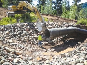
The Poplar River Management Board, formed in 2005 after the river was listed as impaired due to sediment in the water, is working with the Minnesota Pollution Control Agency (MPCA) to use scientific research to figure out the most effective steps to be taken to reduce sediment. A lot of work was done last summer and work will begin again in the spring to complete the Caribou Highlands Flowpath project which will prevent erosion along a section on the east side of the river.

The last of several large Great Lakes Commission (GLC) grant projects aimed at reducing sediment in the Poplar River will begin after the snow is gone. The bid opening was considered very successful, with Reuben Johnson & Son Inc. of Superior being the lowest of 10 bids for the Caribou Highlands Flowpath project that will prevent erosion along a section of the east side of the lower portion of the river.
The $157,000 bid was below the engineer’s estimate of the cost, leaving money left over for other things that had previously been cut out of the project to reduce costs. Cook County Soil & Water hired Barr Engineering to manage the project at a cost of $25,000.
The last two projects to be completed with GLC grant funding, the Mystery Mountain Flowpath and the Lower Eagle Mountain Road, will also be done this summer before the September 30 grant deadline.
After this, all the “low hanging fruit” will have been picked, Poplar River Management Board President Tom Rider reported at the group’s bi-monthly meeting on April 1 – the projects that were considered obvious fixes, such as the Megaslump, will have been completed. Projects from here forward will require sediment sources to be identified more specifically in order to gain maximum benefit from the money that is spent, Rider said.
Karen Evens of the Minnesota Pollution Control Agency (MPCA) said University of Minnesota researcher and professor John Niebur will be suggesting Poplar River projects to his undergraduate and graduate engineering students. She said he wants to have his students identify the most likely high erosion spots along the river. This may involve taking water samples and comparing them to data that has already been gathered.
Lutsen Resort owner Scott Harrison suggested that a hiking path along the east side of the river might be a possible erosion source to study.
Caribou Highlands wastewater pipe
Caribou Highlands has paid to have its wastewater pipe into the river re-designed and has submitted its plan to the MPCA. Cook County Soil & Water District Manager Kerrie Berg and MPCA’s Evens talked about possible funding sources for improvements to the pipe, such as the Iron Range Resource and Rehabilitation Board.
No one has calculated how much sediment has been washing into the river as a result of the water discharged from the pipe, Evens said, but the soil around the end of the pipe has washed away. Discharges from Caribou Highlands’ wastewater lagoons have remained below the level of suspended solids they are allowed to emit. Evens said the expectation when the pipe was permitted was that its design would be changed eventually.
Recommended standards sent to EPA
The MPCA has sent its Total Maximum Daily Load (TMDL) recommendations to the U.S. Environmental Protection Agency (EPA) for approval. Karen Evens said the EPA has directed the MPCA to make some format changes to the document and to provide information on future projections for land use in that area and plans for future projects. After this step, the TMDL will be available for public comment. Evens expects this to be in May.
Having a TMDL in effect can increase the likelihood of obtaining grants, Evens said. The fact that so much land has not been developed in this region offers scientists opportunities to learn how natural processes take their course. “There’s a lot of researchers who want to come up here and use this as a kind of research area,” Evens said.
Within the next 20 years, Evens said, they will have a better idea where and how erosion is likely to occur. This will help in making decisions about building roads and buildings.
The MPCA is working on getting all of the work on the Poplar River onto its website. “If you can’t sleep at night,” Evens said, “pull up the website and start reading!”


Leave a Reply