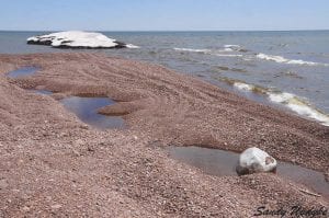
Winter’s gone, and with it most of the snow and most of the cold, but it has left its mark behind in swollen lakes, rivers, streams and ponds.
Recently the National Oceanic and Atmospheric Administration (NOAA) reported that the ice that covered the Great Lakes was the most seen this century. Lake Superior— which still has a lot of ice—was 95 percent covered.
All of that ice cooled the Great Lakes and should lead to lower evaporation rates and a cooler than normal summer. The good news is that this should also lead to a decrease in the chance of wildfires and Great Lakes levels should stay up, states NOAA’s May report.
With the snow melt, streams and rivers are rushing that new water to Lake Superior, which was at an alltime low in 2012.
On May 5, Lake Superior was nearly a foot deeper than last year. The daily mean depth was 601.5 feet while last year it averaged 600.77 feet in May, stated the website for the United States Corps of Engineers which collects and disseminates water level data in cooperation with NOAA and the Canadian Hydrographic Service.
Current water levels in Lake Michigan and Lake Huron are 578 feet while Lake Erie is at 572 feet and Lake Ontario is at a mean average of 246.32 feet for this month.


Loading Comments