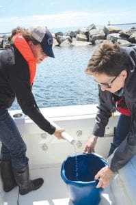
Pictured here is a composite sample being taken, collecting water from three locations and mixing them. The water from the bucket is tested for a variety of chemicals: e-coli, total phosphorus, total chlorophyll-a, total suspended solids, volatile suspended solids, chloride, nitrogen, and nitrate + nitrite. Ilena Hansel (L) and Yvonne Caruthers are pictured sampling the water.

Throughout Cook County, surface water monitoring has been taking place by volunteers. These volunteers are assisting with developing a larger picture of what land use practices are protecting or impacting the water quality in this region. Over the past three summers, Lake Superior has been added to the list of surface water monitoring. Cook Soil and Water Conservation District (SWCD) is working with volunteers and Gary Radloff Jr. of Grand Marais Fishing Charters have been monitoring near shore along the City of Grand Marais shoreline in five locations. Each site is sampled for the same parameters, and the weather is recorded.
Four of the five locations were selected due to their position near stormwater outlets as determined by a prior study of stormwater of the City of Grand Marais. Fishermen and others using the marina selected the fifth location. Compiling water from three places and mixing it for sampling to get a representation of the marina accomplish the testing for this area.
Monitoring takes place from May to October, twice a month, weather and waves permitting. The parameters being monitored at each location include weather conditions, the physical state of the water and the chemical conditions of the water. Chemical conditions are sent off to a lab, following each sampling event.
What is all this monitoring going to tell us, a question often asked? We aren’t sure. It is a project that hasn’t been done too often in the Great Lakes. It is currently set up to determine if stormwater is influencing the near shore water quality through sediment and nutrient loading into the lake. By collecting data, funding dependent, for a minimum of five consecutive years, the data can be used to examine some type of baseline for future sampling events. The data can also be analyzed to look at land use practices’ impact on the water quality. Understanding what the water is carrying with it through runoff of snowmelt, rain water, or from other sources, is important for understanding water quality, which so many people are dependent on for drinking and other species are dependent on for their habitat.
After three years of monitoring, the data is still inconclusive. The data reads similar in numbers, and the samples look good in terms of not exceeding limits for as far as water quality goes for Lake Superior. The impact of rain on the water quality still needs to be examined. A database has been created so that the data can be analyzed each year to understand changes better over time.
Cook SWCD will continue monitoring during the summer of 2017. Volunteers are an essential part of the success of the project. If you would like to volunteer to venture on Lake Superior to do some monitoring, you can contact the office from their website at cookswcd.org. The summary report from the monitoring season is also available through the Cook SWCD office.
This project was funded in part by the Coastal Zone Management Act of 1972, as amended, administered by the Office for Coastal Management, National Oceanic and Atmospheric Administration under Award NA14Nos4190055 provided to the Minnesota Department of Natural Resources for Minnesota’s Lake Superior Coastal Program.


Loading Comments