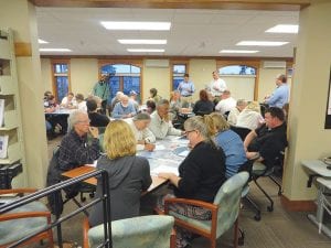
Ideas flowed from the people seated at tables in the Grand Marais Public Library on Thursday, September 4. The main room was used to host a two-hour presentation on possible improvements to the Highway 61 corridor running through Grand Marais, with people asked for their input. Meanwhile, in the children’s library room next door, Bill Barnes, a professional cartoonist, gave a two-hour presentation about how to use computers to animate cartoons, and how to market those cartoons.

Is the Highway 61 corridor running through Grand Marais serving us well as it is currently designed? How can it be improved for safety, economic opportunity, and as the “front door” to our community?
Those questions and many more were the topics of discussion at a public meeting held Thursday, September 4 from 4-6 p.m. at the Grand Marais Public Library.
Sponsored by the City of Grand Marais with assistance from the Sawtooth Mountain Clinic’s Moving Matters project, with free childcare provided by the Cook County Community YMCA, the Thursday evening event attracted about 50 people.
City Administrator Mike Roth kicked off the meeting by outlining several years of planning that led up to the Sept. 4 meeting, beginning with the City of Grand Marais identifying the Highway 61 corridor as an area for improvement in 2012; the city’s 2011 resolution of support for active living; support from citizens at the 2011 Active Living Summit in Grand Marais; and recent financial support towards the community design phase from the Moving Matters project funded by the Center for Prevention at Blue Cross and Blue Shield of Minnesota.
In May of this year, engineers and planners from the Minnesota Department of Transportation (MnDOT) held a “complete streets” workshop in Grand Marais to educate city, county, business and citizens on MnDOT’s policy supporting streets that are safe for bikes, pedestrians and automobiles as well as their interest and role in the Grand Marais Highway 61 redesign process.
Sawtooth Mountain Clinic nurse and Moving Matters project coordinator Kristin DeArruda Wharton introduced the idea of considering the impacts that Highway 61 has on people’s health and safety. She described the process that the city and the clinic will be partnering on to outline those health impacts through a “Health impact Assessment” which will be a part of the public meetings.
Mike Fisher, senior vice president of LHB Engineering & Architects and C.J. Fernandez, a landscape architect with AvenueDesign Partners, facilitated much of the meeting and answered questions.
Once the presentation had been made and the corridor re-design process had been explained, people gathered around tables in small groups to look at maps of the highway corridor.
Each group had the same four questions to consider: 1) How do you use the corridor project area? How often? By what means of transportation? 2) Have you walked or biked along this corridor? Why? 3) How does the corridor change with the seasons? 4) What do you believe are the greatest health concerns in our community?
Participants were asked to circle concerns related in any way to Highway 61.
Each idea was written on a sticky note and pasted onto the map. At the conclusion of the two-hour meeting, the maps were awash in sticky notes. They were collected and the information will be compiled by Fernandez and brought forward at the second of three community meetings, to be held in late October.
Many of the ideas at the tables were the same. They include making better, safer crosswalks; making more accessible parking; traffic enforcement; putting in better signage; adding more trees and flowers; making better, safer bike routes through town; and adding more public washrooms.
Also similar, were the areas identified as “sacred” or not to be messed with, including the harbor front, harbor and lake views, Compass Park, and other iconic historic buildings and areas in the corridor.
Fernandez said this is an initial assessment. “There are a lot of parts to this. We need to get the full backing of the city on this, establish a statement of need, come up with options, get more feedback, do a more thorough process of revision, work with engineers and provide a viable process that can go forward.”
But it isn’t quick. Fernandez said his group worked for three years to complete phase 1 of a two-part project in Loring Park, and it took six years to complete the Highway 61 corridor project that runs through Beaver Bay.
The information gleaned from this first meeting can be seen at http://becausemovingmatters.org/ highway61/. Comments will also be accepted on the website.
Feedback wanted on the Grand Marais Highway 61 corridor
How do you use the corridor project area? How often? By what means of transportation?
Have you walked or biked along this corridor? Why?
How does the corridor change with the seasons?
What do you believe are the greatest health concerns in our community?


Loading Comments