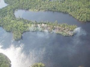
A fire at Gaskin Lake was detected on Monday, June 13. The fire, on a peninsula, is primarily a surface fire. The Forest Service plans to allow the fire to burn to the south and west of Gaskin Lake while limiting the fire spread on the north side. However, the response will change if conditions warrant.

The U.S. Forest Service Gunflint District received information on a wildfire in the Boundary Waters Canoe Area Wilderness on Monday night, June 13, 2011. The fire is located on a small peninsula on the southwest end of Gaskin Lake where it was first detected by campers at about 8:00 in the evening.
Fire personnel completed a reconnaissance flight early Tuesday morning to determine the Forest Service response to the fire. When first spotted it was about three acres in size and smoldering in a mix of white pine cedar and hardwoods. It was not expanding in size and since the expected wind direction for the next few days would be toward Gaskin Lake, and because rain was anticipated, the fire was not expected to enlarge significantly.
On Tuesday afternoon, June 14, one small spot fire was detected on the north side of Gaskin Lake and that fire was contained with Forest Service water drops. On Wednesday, June 15 the fire had grown to a total of six acres. Forest Service spokesperson Mary Ann Atwood said it is primarily a “surface fire” that was burning in the understory of the canopy with an “occasional single tree torching.”
Aircraft continues to monitor the fire and a wilderness crew is on Gaskin Lake to caution wilderness visitors and to provide a surface level review of the fire.
Atwood said the strategy was to allow the fire to burn to the south and west of Gaskin Lake while limiting the fire spread on the north side. She added, “We continue assessing weather forecasts while monitoring the fire’s behavior in order to adjust our strategy as appropriate.
“Our response could change if conditions warrant,” she said.
The cause of the fire is unknown at this time. Atwood said a crew is headed to the area to assess the possible cause.
Gaskin Lake is in the BWCAW about 2 ½ miles southwest of Poplar Lake and just north of Winchell Lake.


Loading Comments