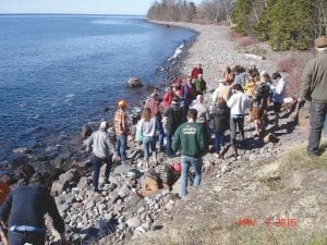
Jim Starr, a Hovland resident, had some company on May 7, 2016 as a group from The Institute on Lake Superior Geology made their way along the North Shore, stopping at various points along the way.
The institute is a nonprofit organization that has been meeting annually since 1955 at various locations near Lake Superior in both the U.S. and Canada. Professional geologists, industry professionals, and students come to participate in field trips and technical presentations highlighting the unique geology of the Lake Superior region.
“The Institute on Lake Superior Geology has been around for a long time. It functions on a volunteer basis,” said Terry Boerboom, one of the institute’s members. “It’s a lot of work and some leg-pulling to put the meeting together every year, but it is also a lot of fun, and we all stay up to date on the latest happenings in the geology of the region. We like to show each other what we have been working on.”
This year, the institute’s 62nd annual meeting took place in Duluth. The group that visited Starr’s property was one of several field trips that took place before and after the meeting and was led by Boerboom, a geologist from the Minnesota Geological Survey, and John Green, also a geologist and a professor at the University of Minnesota Duluth. They covered a lot of ground, making the trek from Duluth to Grand Marais.
The group’s trip was an opportunity to see specific geologic features of the lakeside that Cook County residents or our many visitors may not usually consider when walking along the shore and enjoying the beautiful view, but could appreciate just as well.
According to Boerboom, the rocks along the shore of Lake Superior between Duluth and the Canadian border by Grand Portage are over 1 billion years old and formed when the North American continent began to drift apart along the axis of Lake Superior. The geologic activity during that time has left the North Shore with abundant volcanic rocks, many of which were highlighted on the trip.
Boerboom explained that at many places along the shore, such as Sugarloaf Cove, individual lava flows can be identified and distinguished from the next by the bubbly surface that formed near the top of each flow as it cooled.
“The people who attended this trip ranged from college students just learning about geologic events to seasoned professionals who have read about these rocks but may have not had the opportunity to see them firsthand,” said Boerboom.
Just another way to appreciate the area our small communities have settled in.


Loading Comments