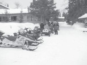
The Cook County Ridge Riders Snowmobile Club hosted another fabulous Fun Run on Saturday, February 4. There were 150 riders—from Cook County and far beyond—registered and on the trails, riding from Devil Track Landing to points up the Gunflint Trail. Top: Snowmobilers stretch their legs at Gunflint Lodge. Above left: There were fun games and raffles—a meat raffle, a balloon raffle and a raffle for cash. Ian McCumer (left) won $500 and Jerry Paine won $200. Upper right: Matt Schliep of Grand Marais won the grand prize $1,000. It was so much fun the Ridge Riders said they would do it again next year. Mark your calendar for the first weekend of Feb. 2013.

Recent snowfall in northeastern Minnesota has allowed for the start of the 2012 aerial moose survey, according to the Minnesota Department of Natural Resources (DNR). The annual survey, which has been conducted every year since 1960, provides critical data needed to determine the size of the moose population and to set the number of moose hunting permits.
Observers from the DNR Fish and Wildlife Division, the 1854 Treaty Authority, and the Fond du Lac Band of Lake Superior Chippewa gathered in Ely to begin the survey, which is expected to last two to three weeks, depending on the weather. Forty-nine survey plots randomly scattered across the survey area will be flown. This includes the addition of nine specially selected “habitat” plots that will be studied to determine how moose respond to recent wildfires, prescribed burns and timber management. Survey plots measure approximately three miles wide by five miles long.
“We are glad to see the snow and get the survey started,” said Tower Area Wildlife Manager Tom Rusch. “We plan to fly two aircraft and survey up to eight plots per day. We’re flying over some of the most rugged areas of the state during these surveys, so safety and weather conditions are always a concern for our crews.”
Until recently, only 2 to 4 inches of snow covered the ground in some of the western portion of the survey area, which caused a three-week delay. Snow cover of at least 8 inches is needed to cover rock outcroppings and allow field observers to identify moose in heavy cover. Once all of the plots have been flown, the data will be analyzed to estimate the total number of moose in the area, the level of reproduction, and the ratio of adult bull and cow moose. Data from the survey will be used in the process to set permit numbers for the 2012 hunting season.


Loading Comments